
I was at one of the IITs recently, surrounded, as one tends to be, by engineers.
There is a particular way engineers are trained to imagine software. Reality becomes a table. The table becomes a database. The database gets APIs, dashboards, analytics and, increasingly, an AI layer on top. Eventually someone calls it a digital twin.
Which raises a fairly fundamental question: why do we need 3D at all?
Is 3D simply an augmentation of user experience—a more impressive way of looking at information we already have? Is it the equivalent of replacing a spreadsheet with an immersive interface?
Or is the ability to reconstruct reality, on demand, and then simulate strategies against that reconstruction actually fundamental to what a digital twin is supposed to do?
The military makes the answer easier to see.
The problem has historically moved through three stages: reconnaissance, reconstruction and strategic planning.
First, understand what exists in the theatre. Then construct a sufficiently faithful model of it. Then test what happens if you act.
Increasingly, all three need to happen at the edge. The value of knowing reality declines rapidly if the information arrives after the operational decision has already been made.
The civilian problem is less urgent in minutes and seconds, but vastly harder in scale.
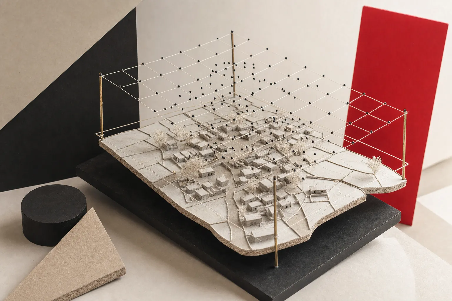
We have to reconstruct cities.
And villages.
Road networks, drains, buildings, utilities, trees, construction sites, floodplains and informal settlements.
So before asking whether India needs digital twins, perhaps there is a simpler question:
At what resolution do we need to understand reality for a particular decision to become possible?
Every resolution creates a different set of decisions
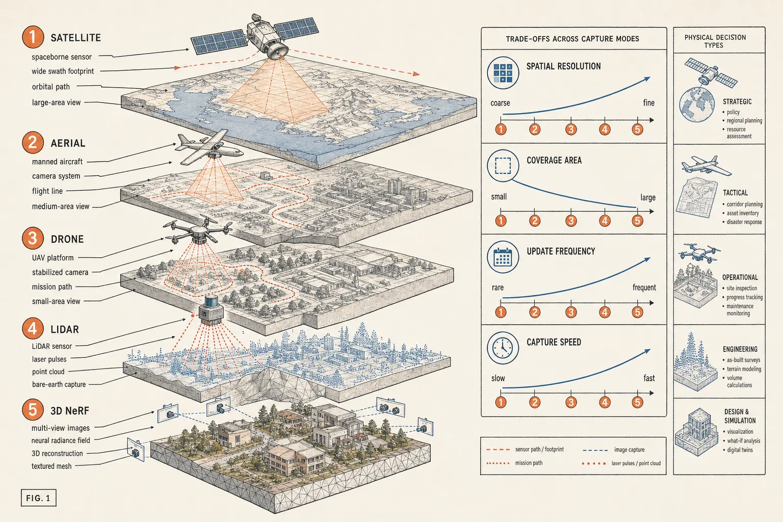
A satellite image covering hundreds of square kilometres is enormously valuable.
At relatively coarse resolution, I can understand urban expansion, changes in vegetation, water bodies, large infrastructure and patterns of land use.
Go down to roughly 30 centimetres and another class of decisions becomes possible.
I can identify building footprints reasonably well. I can see new construction. I can compare cadastral boundaries against what appears to be occupied land. At sufficient quality and with the right temporal comparisons, I can begin to detect encroachments.
But suppose somebody adds another floor to an existing building.
From directly overhead, the footprint may barely change.
The information I need is no longer primarily in x and y. It is in z.
So I need something else.
Stereo imagery. Oblique imagery. A surface model. Photogrammetry. LiDAR. Aerial capture.
Move further down, to sub-10-centimetre imagery collected from aircraft or drones, and another set of objects begins to become visible. Road defects. Small rooftop structures. Drainage features. Street furniture. Boundary walls. Construction details.
Go into dense 3D reconstruction and I can ask questions about height, volume, slope, visibility, clearance and physical relationships.
LiDAR becomes useful not because it produces a prettier picture but because sometimes geometry itself is the data.
A few centimetres of elevation can determine where water flows.
The height of a wire matters.
The clearance under a bridge matters.
The difference between the top of a drain and the level of the road matters.
Whether a tree canopy hides the terrain matters.
And this is why the argument cannot simply be satellite versus aircraft versus drone versus LiDAR versus NeRF.
They are not competitors in the conventional sense.
They sit at different points on a curve of coverage, resolution, frequency, geometry, latency and cost.
Satellites give you enormous scale and repeatability.
Aircraft can give you city-scale centimetre imagery without requiring thousands of individual drone missions.
Drones let you capture smaller areas at extremely high resolution, quickly and on demand.
LiDAR gives you direct geometric information where imagery would otherwise have to infer it.
NeRFs and newer reconstruction techniques give us something different again: the ability to reconstruct and move through a scene from imagery with a degree of realism that was extraordinarily expensive only a few years ago.
But photorealism is not the same thing as measurement.
A reconstruction can look exactly like a street and still not be something on which you adjudicate a property boundary.
The important question is therefore not: Which technology is best?
It is: What is the cheapest representation of reality that is sufficiently accurate for the decision I need to make?
"Why SWAMITVA?"
A few years ago, I was at a GeoBuiz conference in San Francisco.
Robert Cardillo, former Director of the U.S. National Geospatial-Intelligence Agency, was discussing geospatial intelligence.
At some point, SWAMITVA came up.
His reaction was essentially: Why SWAMITVA?
And then there was a pause.
He nodded slightly, looking somewhere into the distance, as if the answer had just occurred to him.
Oh.
You guys have different problems.
More foundational problems.
It hurt a little.
But it was true.
The United States could talk about persistent intelligence, high-frequency observation and ever richer representations of the physical world.
We were still solving the problem of knowing, authoritatively, where people's properties were.
In large parts of rural India, there simply wasn't a sufficiently precise spatial record of inhabited village land.
Before sophisticated simulations of villages, we needed maps of villages.
Before asking what would happen to an asset, we needed to know where the asset was.
Before building the twin, we needed the base reality.
There is something deeply unglamorous about this.
And extremely important.
Do the simple thing first
There is a perfectly sensible instinct in government technology: Do the simple thing first.
Make the registry.
Make the database.
Make the Excel sheet.
Give every asset an ID.
Record who owns it, where it is supposed to be and what happened to it.
There are enormous parts of Indian governance where doing just this properly would be transformative.
But there is also a point at which the abstraction breaks.
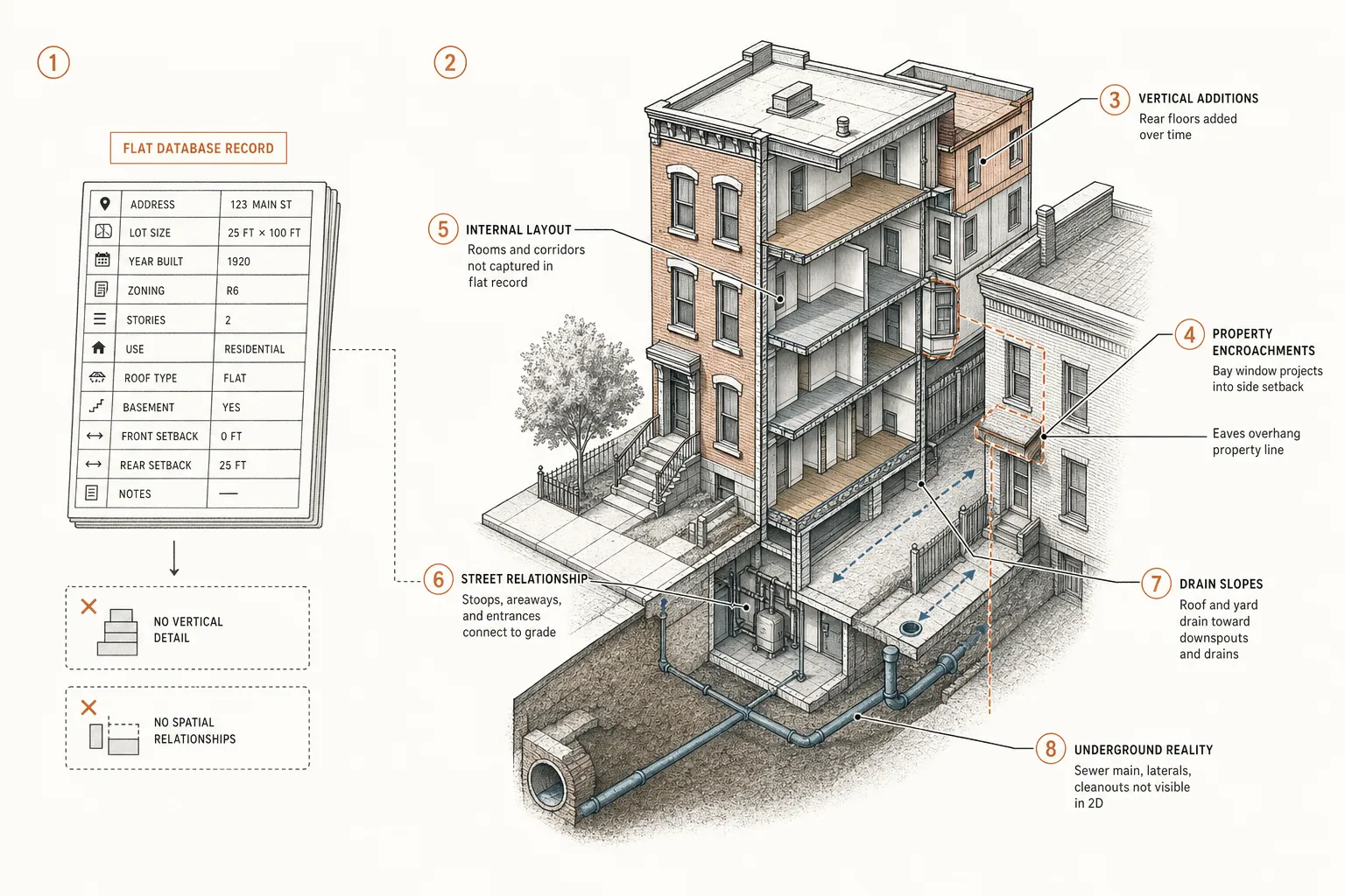
An Excel row can tell me there is a road.
It cannot tell me what the road looks like.
A property database can tell me a building has two sanctioned floors.
It cannot tell me that a third one appeared last month.
A drain registry can tell me a drain exists.
It cannot tell me whether construction has altered the slope of the neighbourhood such that water can no longer reach it.
A tree inventory can tell me that 132 trees were planted.
Reality can tell me that 47 survived.
And that distinction matters enormously in India.
Because the gap between what our systems say exists and what physically exists is often the problem itself.
From record to reality
There is a progression in how governments can understand their territory:
Record → Locate → Observe → Reconstruct → Understand → Simulate → Decide
Most digitisation programmes begin with the first one.
What records do we have?
Then GIS adds location.
Where is it?
Remote sensing adds observation.
What does it look like now?
Repeated observation creates change detection.
What has happened?
3D reconstruction adds physical structure.
What actually exists in space?
And once the representation is sufficiently accurate, simulation becomes possible.
What happens if I intervene?
That is where the idea of a digital twin becomes genuinely interesting.
Not when a commissioner can rotate a beautiful 3D model of a city on a large screen.
But when that representation allows us to test decisions before imposing them on the physical world.
Suppose this neighbourhood densifies by another 20 percent. What happens to drainage?
Suppose I raise this road by 30 centimetres. Where does the water go?
Which buildings become inaccessible during a one-in-ten-year flood?
Where will a proposed flyover create new blind spots or bottlenecks?
Which road segment is most likely to fail next?
What happens to pedestrian movement if this intersection is redesigned?
Where has construction exceeded what was sanctioned?
Which public land has gradually disappeared into private occupation?
Those are not visualisation questions.
They are decision questions.
And suddenly the requirement for a better representation of reality makes sense.
India can skip a generation
The slightly uncomfortable truth in Cardillo's observation was that India had base-layer problems that developed geospatial economies had solved decades earlier.
But there is another way of looking at the same problem.
We may be solving those foundational problems at exactly the moment when the economics of observing and reconstructing reality are changing dramatically.
Satellites are improving.
Aerial imagery is becoming more accessible.
Drones have made extremely high-resolution capture routine.
Photogrammetry has become dramatically cheaper.
LiDAR is moving into more platforms.
Computer vision can parse scenes automatically.
Vision-language models can increasingly turn every frame into something that can be queried in words.
3D reconstruction techniques are improving at an extraordinary pace.
And compute is moving closer to the sensor.
The distance between reconnaissance, reconstruction and reasoning is collapsing.
Which means India does not necessarily have to reproduce the exact technological progression followed elsewhere.
We can build the registry and the living representation of reality almost together.
SWAMITVA is interesting precisely because of this.
On the surface it is a programme about property records.
Underneath it is something more consequential: the creation of a high-resolution spatial base layer for hundreds of thousands of villages that previously did not possess one.
Once that layer exists, a completely different set of questions becomes possible.
And perhaps this is the right way to think about 3D in India.
Not as the next fashionable interface.
Not as something every government department must procure because someone has put digital twin into a tender.
And certainly not as an excuse to model everything at the highest possible resolution.
Instead: Start with the decision.
Ask what the decision requires us to know about reality.
Then determine the minimum resolution, frequency and dimensionality required to know it.
Sometimes the answer will be a database.
Sometimes a satellite image.
Sometimes 30-centimetre imagery.
Sometimes 5-centimetre aerial capture.
Sometimes a drone.
Sometimes LiDAR.
Sometimes a continuously reconstructed 3D environment.
The sophistication should follow the problem, not precede it.
But we should also recognise something that the age of databases made easy to forget.
The world is not a table.
India, especially, refuses to behave like one.
Its buildings grow vertically and informally. Its roads change width. Its drains disappear beneath construction. Its addresses mutate. Its cadastral maps and physical occupation diverge. Its infrastructure is added, removed, repaired and appropriated faster than most registries are updated.
So yes: do the simple thing first. Make the registry. Make the Excel sheet.
But understand what those abstractions cannot contain.
Because no registry, and certainly no Excel sheet, captures the physical reality of India.
And if digital twins are to mean anything more than another generation of dashboards, their purpose is ultimately to close precisely that gap:
the gap between the India described by our systems and the India that actually exists.